I like a good name, and geographical features attract some of the best. Aoraki. Desolation Sound. Head-Smashed-In Buffalo Jump. Tierra del Fuego. Some names are descriptively apt. Others less so: Desolation Sound captures the mood of the map-maker, rather than the place itself. The Broken Islands is a perfect descriptor for this fragmented cluster of forested rocks on the west coast of Vancouver Island. The islands are within Barkley Sound, south of Ucluelet, and comprise a unit of the federally-managed Pacific Rim National Park Reserve (the other two units are Long Beach, between Tofino and Ucluelet, and the West Coast Trail). Our last trip of the summer was spent kayaking in the Broken Islands with friends Dan and Lesley. We spent five days on the water, camping on three different islands, and experiencing the variety the coast offers.

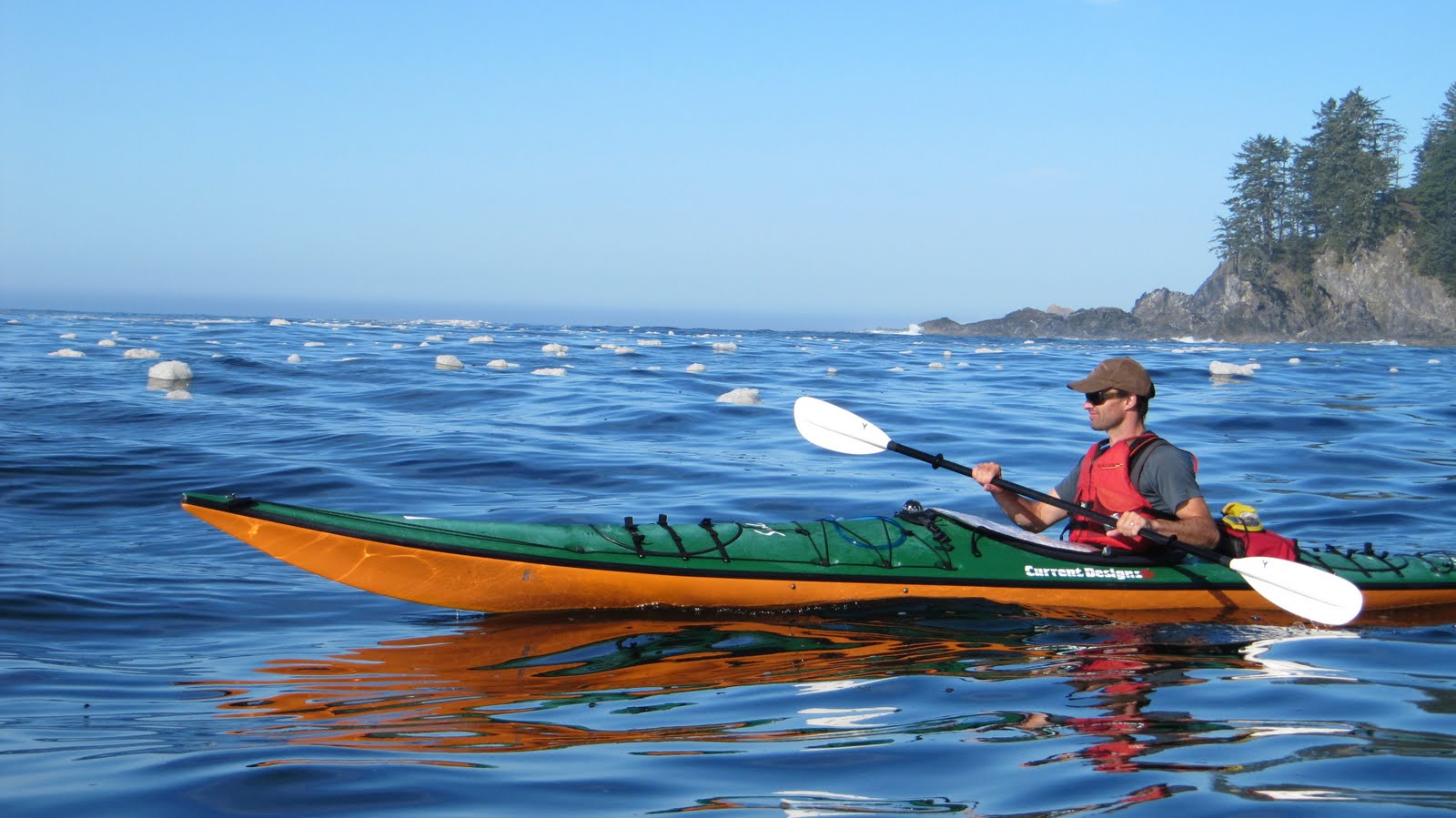
We put into the water at Toquart Bay, having rented kayaks - Current Designs Solstices - from Majestic Ocean Kayaking in Ucluelet. Our first crossing, from the bay to the Stopper Islands, loosened up spines, shoulders and wrists. We passed through the channel bisecting the Stoppers, stopped for a bite and some adjustments, and then crossed a wider channel to Lyall Point. The fog cover began to lift from the surrounding landscape. We entered the park near Hand Island, navigating between Hand's western shore and a off-lying islet. We left Hand and passed through a channel between the Brabant Islands. The sun began to shine as we crossed over Peacock Channel and approached Dodd Island. Crossing Peacock we encountered signs of red tide, a seasonal toxic algal bloom which makes shellfish off-limits. The water was a muddy reddish-brown.
 |
| Approaching Dodd Island. |
We pulled up to the beach on the eastern point of Dodd, location of one of the park's seven dedicated campsites. We caught some sun and explored the point. A flotilla of four double kayaks beached and we decided to continue on to Willis Island and explore its camping options. We set up camp under cedar trees above a pebbly beach. Sarah and I swam, briefly. The water was cold, but not as cold as I expected. Sarah cooked chili con carne for dinner, and we enjoyed a clear sunset.
 |
| Dinner site on Willis Island. |
Next morning we woke to dense fog hanging over the water. We ate breakfast, packed up camp and were on the water as the fog lifted. Our destination was Clarke Island, in the south west corner of the park. We paddled around the western end of Willis and crossed Thiepval Channel to a chain of islands, including Turrent and Trickett. The tide was low, preventing passage through the first channel we approached, but we negotiated our way between the chain of islands, and bee-lined for Clarke. We approached Clarke from the north west, sneaking between barnacle-encrusted outcrops and kelp beds into a small lagoon on the west side of the island. A mink was spotted on one of the little islands offshore. We landed on a white sandy beach with western exposure. Sarah and I continued around to investigate a bay on the island's south side, before returning to set up camp. We ate lunch and then entered the water again. Passing through the channel between Clarke and Benson, an island to the south, we returned to Turrent Island, this time exploring the sheltered waters of its southern coast. We saw numerous sea stars (starfish) including bat stars, mottled stars, and one or two sun stars, but we failed to locate Turrent's giant Sitka spruce.
 |
| Bat star, Asterina miniata. |
 |
| Turning it up for the camera, off Turrent Island. |
Our return to Clarke was into a decent head wind, but conditions were fine on the beach. I had started
Wade Davis's
The Wayfarers, and reading his chapter on the extraordinary Polynesian navigation and settling of the Pacific felt appropriate. As evening fell we heard loud mewling and rustling from the dense bush behind our tent site. We realized the mink had her den there, with young to feed.
 |
| Sunset on Clarke Island. |
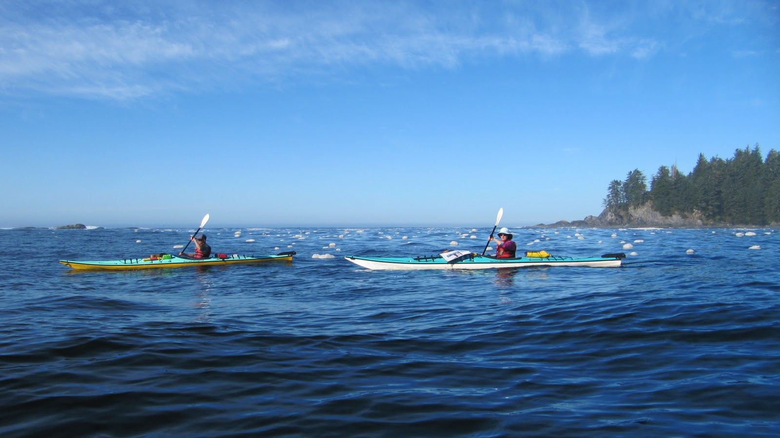
The middle day of our trip was dedicated to exploring the outer islands of the Broken Group. Once again we passed between Clarke and Benson. Conditions were perfect for crossing Coaster Channel, the largest open-water stretch within the park. We passed to the north of Verbeke Reef, as the Pacific swell crashed against the exposed rock. Around us was an ocean of suds, carpets of foam thrown up by the friction between wave and rock.
 |
| Entering the suds. |
 |
| Dan and Lesley, perfect paddling conditions. |
We left the shelter of islands and outcrops and entered what I wanted to call the open ocean, despite the proximity of land. Japan was on my right, Vancouver Island to my left, and we were riding 5-6 feet of swell. The experience aboard a kayak was somewhat disorientating. When I focused on paddling, I barely noticed the sweep of the swell passing beneath me. Looking at the paddlers around me, watching as they sunk into a trough or rose high on the crest of the swell, brought home the size and strength of the swell. We passed the outside of an unnamed island, a mound of rock capped with forest, the cliffs on its south western shore battered by the incoming waves, and approached Wouwer Island. We entered a channel between Wouwer, on the outer, and Batley. Paddling the inner coast of Wouwer, we came out between the island and another, Howell, that bore the brunt of the Pacific swell. Sea lions basked on rocks between the two islands, uttering warning grunts to the kayaks passing by.
 |
| Between Wouwer and Howell. |
We followed the northern coast of Howell, and then crossed over to Dicebox Island, navigating past isolated outcrops of rock topped by hardy spruce and other vegetation clinging on to their slice of paradise. Dicebox was once the location of a Nuu-chah-nulth village and fortification. Indeed, eighteen historical First Nations village sites have been identified within the Broken Island Group. The numerous clam and oyster beds, the clusters of mussels - all frustratingly inedible due to the red tide - attested to the bounty of the region. We later came across
CMTs - culturally-modified trees - on Effingham Island: cedar stripped of its outer bark, the purpose being the use of cedar fibres for making clothing. Landing at Dicebox was a little tricky, as the beach was steep and a bit rocky, and small curlers kept my kayak in motion. I managed to eject without tipping myself into the water, and we lunched in the sun.
 |
| On Dicebox. |
From Dicebox we paddled south east toward Cree Island, and then north towards Effingham Island, the largest island in the Broken Group. We passed through bull kelp beds, spying spider crabs clinging to the stems. A large sea cave on Austin Island held our attention. The coast along this stretch was shaped by its exposure to the Pacific, with high cliffs in places, and wave-shaped formations.
 |
| East of Austin Island. Imperial Eagle Channel and the open Pacific are beyond. |
We cut west between Austin and Effingham and followed the coastline clockwise into Effingham Bay. After a brief exploration of Effingham, including our discovery of the culturally-modified trees, we started back towards Clarke. As we left the shelter of Effingham and Gilbert, the island adjacent, we encountered the forecasted south-westerly winds. We made our way to Cooper Island and beached to take stock. Whitecaps on Coaster Channel indicated a decent rate of knots. Fog was being blown through, low and thick in places. After listening to the radio broadcast, we decided to make the crossing before the wind increased in strength.
 |
| On Cooper Island, looking south. |
We passed through the channel between Cooper and Camblain, trying to exploit the shelter of the landmasses between us and the open ocean. The wind combined with the swell as we entered the channel, making it difficult to keep our noses pointed towards our destination. We detoured around a reef and paddled the last stretch into the wind. Wisps of fog swept overhead. We passed by a bald eagle clinging to a straggly shrub on the rocky reef, its feathers in disarray. We landed on Clarke, bushed. The wind died away as dinner was prepared. Dan lit a fire and I fried cookies. We spotted the mink again, cruising the shoreline and foraging for food.
The following morning we departed for the north east corner of the park. We made our way to Thiepval Channel, and then passed into the sheltered waters between Dodd, Willis and Turtle Islands. We turned east, negotiating the islets of the Tiny Group, before entering the lagoon between Jarvis and Jaques Islands at high tide. Within, we floated above a fish trap, a stone structure designed to capture fish as the tide recedes.
 |
| Entering the lagoon, Jarvis Island on the left, Jaques on the right. |
After a stately dawdle around the lagoon, we exited via the north entrance and tracked along Jaques's coast to Gibraltar Island. The campsite there was primarily in the shaded forest of the island's north coast, but a small spit out to a rocky outcrop kept us in the sun. We were second to Gibraltar, but landed superior tent sites, under demi-giant Western Redcedar and overlooking the water. Dan checked his phone messages and learned there had been an earthquake off the west coast of Vancouver Island that afternoon. We'd been on the water and hadn't felt a thing. We swam, followed circuitous trails in the forest, and cruised the tide pools, studying anemone cities and hermit crabs at work. Later that night we lit a fire and consumed one or two mugs of vino tinto.
 |
| Decent-sized cedar on Gibraltar Island. |
 |
The view north west from Gibraltar. Jaques Island is obscured,
Erin and Nettle Islands are to the right. |
Our last day was eventful. We broke camp and paddled north to Nettle Island, making our way up between Nettle and the smaller Denne Island. The foresters in the group exclaimed over the white pine evident on Denne's slopes. We tracked between Denne and Prideaux. Before us was a stretch of water where two channels merged, Sechart and Peacock, where we spied a humpback whale in the distance. It disappeared from view, before rising some moments later much closer to us, heading past us toward Gibraltar. We carried on, crossing Sechart Channel and the park boundary as we passed a couple jigging for ling cod, and landing on Capstan Island, one of the Pinkerton Islands, for lunch. After lunch we encountered another humpback whale, rising and blowing three times before disappearing from view, as it headed east along Sechart. We passed through the Pinkertons and followed the coast of Vancouver Island, arriving again at Lyall Point, our last resting place before we entered the Broken Islands four days previous. We crossed to the Stopper Islands, where we witnessed an acrobatic display of feeding in the channel between the two islands, as a sea lion decimated a ball of fish, leaping, twisting and curling after the small silvery flashes of flesh. We slowly paddled the last stretch to Toquart Bay, not quite ready to finish the trip, weary but satisfied with our exploration of the Broken Islands.
 |
| Peachy sunset on Gibraltar. |